Disconnected by Design: Why America's Conservation Data Crisis Is Undermining Ecosystem Science—and How GIS Integration Can Rebuild the Picture
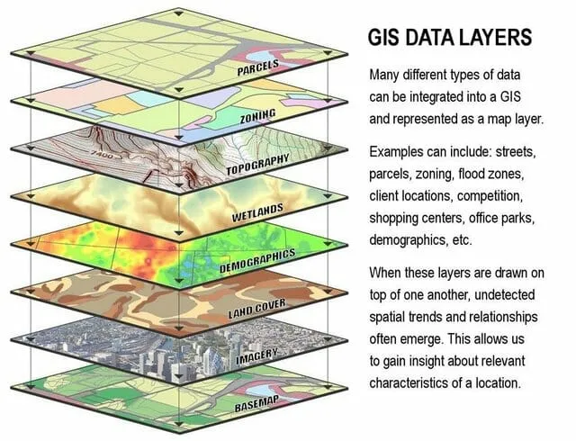
Photo: GIS data layers maps overlapping geographic information systems conservation planning, via manual.giscloud.com
America's conservation enterprise is, in many respects, a data-rich endeavor. The U.S. Fish and Wildlife Service maintains species occurrence records. The Environmental Protection Agency tracks water quality across thousands of monitoring stations. The USDA Forest Service logs vegetation cover, disturbance events, and timber harvest activity. State wildlife agencies generate their own biodiversity inventories. And hundreds of nonprofit organizations contribute field observations, camera trap footage, and habitat assessments to the broader scientific record.
On paper, this sounds like an abundance of information. In practice, it amounts to something far less useful: a vast, fragmented archive that no one can fully read.
The problem is not the volume of data. It is the absence of a shared language, a common spatial framework, and the institutional infrastructure to bring these datasets into conversation with one another. As a result, conservation managers routinely make decisions about land use, species protection, and habitat restoration without access to the complete picture that already exists—somewhere, in some database, in some format that their systems cannot parse.
A Mosaic of Incompatible Systems
To understand the scale of the problem, consider what happens when a federal land manager in the intermountain West attempts to assess the ecological condition of a watershed that crosses jurisdictional boundaries. Portions of that watershed may fall under the purview of the Bureau of Land Management, the U.S. Forest Service, a state fish and game department, and one or more tribal nations. Each entity collects data according to its own protocols. Coordinate systems differ. Classification schemes for vegetation types are inconsistent. Species naming conventions vary between taxonomic authorities. Temporal resolution—the frequency at which data is collected and updated—is rarely synchronized.
The result is a mosaic of incompatible records that resists integration. A researcher attempting to model habitat connectivity across that watershed must spend an estimated sixty to eighty percent of their project timeline on data cleaning and harmonization before a single analytical map can be produced. That is not science. That is overhead—and it comes at a direct cost to conservation outcomes.
This inefficiency has been documented repeatedly. A 2021 assessment by the National Academies of Sciences found that data interoperability gaps represent one of the most persistent structural barriers to effective biodiversity monitoring in the United States. The assessment noted that no single federal agency currently holds either the mandate or the resources to establish a unified national framework for ecological data.
The Political Architecture of Fragmentation
The data crisis is not purely a technical failure. It is, in large part, a product of the political architecture that governs American environmental management.
Federal conservation authority is distributed across at least a dozen major agencies with overlapping but non-identical missions. Each operates under distinct congressional appropriations, different statutory authorities, and separate information technology procurement processes. When agency A invests in a new data management platform, there is no mechanism compelling agency B to adopt compatible standards. Interagency coordination exists, but it is voluntary, episodic, and frequently underfunded.
State governments add another layer of complexity. Wildlife management authority in the United States is constitutionally grounded at the state level for most non-migratory species. This means that fifty separate agencies maintain fifty separate data systems, each shaped by local legislative priorities and budget constraints. Some states have made significant investments in modern geospatial infrastructure. Others operate on legacy databases that predate widespread GIS adoption.
Nonprofit organizations, which collectively generate an enormous volume of field-based ecological data, face their own constraints. Many lack the technical capacity to format data for interoperability. Proprietary concerns, grant reporting requirements, and institutional incentives that reward data collection over data sharing further impede the flow of information into shared repositories.
Where GIS Integration Has Demonstrated What Is Possible
Despite these structural barriers, a number of initiatives have demonstrated that unified geospatial frameworks can materially accelerate conservation outcomes when the necessary institutional alignment is achieved.
The Landscape Conservation Cooperatives, established under the Obama administration, represented one of the more ambitious attempts to build regional data integration networks. At their peak, these partnerships brought together federal agencies, state governments, tribes, and universities around shared geospatial platforms for landscape-scale conservation planning. Where they functioned well—as in portions of the Gulf Coastal Plains and Ozarks region—they enabled coordinated habitat restoration efforts that would have been logistically impossible under fragmented data conditions.
The NatureServe network offers another instructive example. By maintaining a standardized taxonomy and geospatial database of species occurrence records drawn from state natural heritage programs across the country, NatureServe has created one of the most comprehensive biodiversity datasets available in North America. Conservation planners routinely use this integrated resource to identify priority areas for protection and to assess the adequacy of existing reserve networks—tasks that would require prohibitive effort if each state's records had to be queried individually.
More recently, the Biden administration's America the Beautiful initiative, which set a goal of conserving thirty percent of U.S. lands and waters by 2030, has intensified pressure on federal agencies to develop interoperable data systems capable of tracking progress toward that target. The initiative has catalyzed new investments in the USGS National Land Cover Database and has renewed interest in the Protected Areas Database of the United States as a shared spatial accounting tool.
The Technical Framework GIS Provides
Geographic information systems are uniquely suited to the challenge of data integration precisely because space itself is a universal organizing principle. Regardless of which agency collected a dataset or which classification scheme it employed, ecological phenomena occur at specific locations on the earth's surface. A common spatial reference framework—a shared coordinate system, a standardized grid—provides a foundation on which disparate datasets can be overlaid, compared, and analyzed together.
Modern GIS platforms support data federation approaches that do not require agencies to abandon their existing systems. Instead of forcing all parties to migrate to a single centralized database—a politically and logistically fraught proposition—federated architectures allow distributed datasets to be queried through a unified interface while remaining stored in their original locations. Agencies retain control over their data while making it discoverable and analytically accessible to partners.
Cloud-based geospatial platforms have further reduced the technical barriers to integration. Tools such as ESRI's ArcGIS Online and open-source alternatives including QGIS and Google Earth Engine allow analysts to pull from multiple data sources simultaneously, apply consistent analytical methods, and produce outputs that can be shared across institutional boundaries at minimal marginal cost.
The remaining obstacles are less about technical feasibility than about governance. Who maintains the integration layer? Who sets the metadata standards? Who arbitrates when agencies disagree about classification schemes? These questions require sustained institutional commitment—and, ultimately, federal policy that creates durable incentives for interoperability rather than leaving it to voluntary goodwill.
Toward a National Ecological Data Infrastructure
Conservation scientists and GIS professionals have articulated a vision for what a genuinely integrated national ecological data infrastructure might look like. It would incorporate standardized spatial data exchange formats, mandatory metadata requirements for federally funded ecological monitoring, and a permanent interagency body with the authority and resources to maintain integration standards over time.
Several analogies from adjacent domains suggest this is achievable. The National Weather Service operates a highly integrated data infrastructure that draws from thousands of ground stations, satellite feeds, and modeling systems maintained by different entities—and produces actionable, real-time products that inform decisions across the entire economy. There is no technical reason a comparable infrastructure cannot be built for ecological data.
The consequences of continued fragmentation are not abstract. Every year that conservation managers operate without integrated data is a year in which species monitoring gaps go undetected, habitat restoration efforts are duplicated in some areas while neglected in others, and early warning signals of ecosystem stress are missed because no one is watching the complete picture.
GIS integration will not resolve every conservation challenge facing the United States. But it is difficult to identify a conservation challenge that would not benefit from a more complete, more coherent, and more accessible view of the ecological systems we are trying to protect. The data exists. The tools exist. What remains is the institutional resolve to connect them.