Ruins as Refuge: What GIS Analysis Is Telling Us About Wildlife Thriving in America's Forgotten Industrial Wastelands
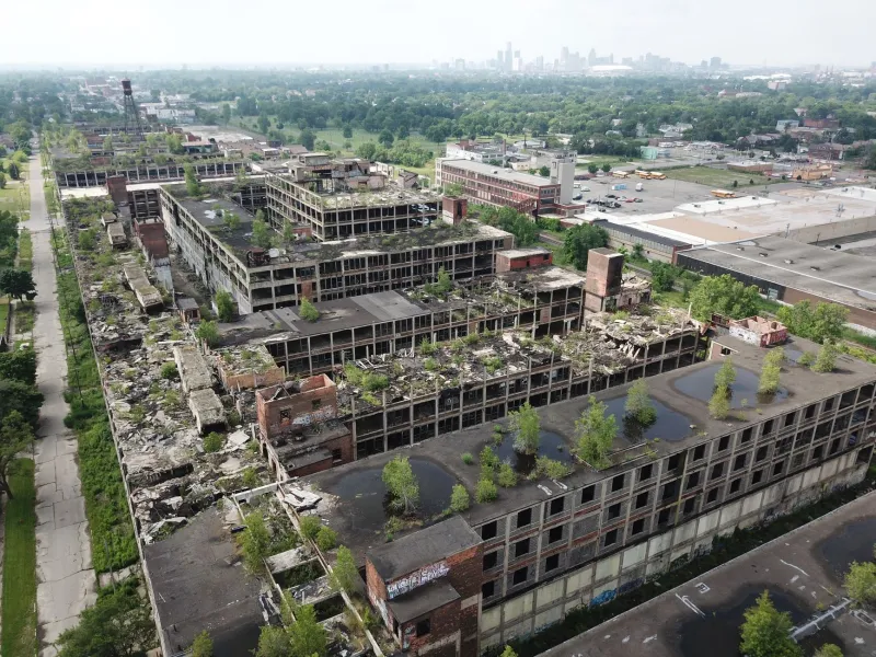
The American conservation imagination has long been organized around a particular aesthetic—pristine forests, unbroken wetlands, mountain ranges untouched by industry. What that imagination struggles to accommodate is the idea that a crumbling coke plant in western Pennsylvania, or a shuttered copper smelter on the outskirts of a Montana town, might be doing conservation work that a formally designated nature reserve cannot. Yet that is precisely what an emerging body of geospatial research is beginning to document.
Using satellite imagery, land-cover classification models, and wildlife movement data layered against historical industrial footprints, researchers are mapping a category of habitat that has no official standing in American conservation policy but is increasingly difficult to ignore: the brownfield ecosystem.
The Invisible Landscape Layer
The United States Environmental Protection Agency estimates that there are more than 450,000 brownfield sites across the country—properties where expansion, redevelopment, or reuse may be complicated by the presence or potential presence of hazardous substances. For decades, these sites have been understood almost exclusively through the lens of contamination liability, remediation cost, and urban redevelopment opportunity. Their ecological dimensions have received comparatively little systematic attention.
That gap is beginning to close. Geographic information systems have made it substantially easier to overlay the spatial footprint of abandoned industrial land with remotely sensed vegetation data, species occurrence records drawn from databases such as iNaturalist and eBird, and connectivity models originally designed to assess movement potential across fragmented natural landscapes. When researchers apply these tools to brownfield inventories, patterns emerge that challenge the standard assumptions about what these sites are and what they are doing.
In the post-industrial corridor stretching across parts of Ohio, West Virginia, and Pennsylvania—a region where steel, coal, and chemical manufacturing left behind an intricate mosaic of disturbed land—GIS-based habitat analysis has identified clusters of abandoned industrial properties that are now supporting grassland bird species, early-successional forest communities, and in several documented cases, populations of state-listed reptiles and amphibians. These are not incidental sightings. The spatial data suggest that in some instances, the brownfield patches are functioning as stepping stones within larger movement corridors, connecting forest remnants that would otherwise be effectively isolated by the surrounding matrix of suburban development and active agriculture.
Why Ruins Work as Habitat
Understanding why abandoned industrial sites can support meaningful wildlife populations requires moving beyond the contamination narrative—without dismissing it. The ecological dynamics at work are genuinely complex.
Many brownfield sites share structural characteristics that, whatever their origins, create conditions favorable to certain wildlife communities. Decades of abandonment produce successional vegetation sequences that are increasingly rare in intensively managed agricultural and suburban landscapes. The heterogeneous microtopography left by earthmoving operations, subsidence, and structural collapse generates a variety of microhabitat niches. Reduced human disturbance—a consequence of liability concerns and restricted access—creates de facto refugia from the predation pressure and behavioral disruption that characterize more accessible open spaces.
GIS analysis adds a spatial dimension to these ecological observations. Connectivity modeling, which uses cost-surface algorithms to estimate the relative ease with which animals can move across different land-cover types, consistently identifies abandoned industrial sites as lower-resistance pathways than the surrounding developed landscape. A former rail yard overgrown with native shrubs and early-successional trees may present far less movement resistance to a wide-ranging mammal than the active commercial corridors on either side of it. In a fragmented landscape, that difference can be decisive.
Case Studies in Unintended Conservation
The former Bethlehem Steel site in Lackawanna, New York, offers one of the more extensively documented examples. The sprawling complex, which ceased steel production in the 1980s, has been the subject of ongoing remediation and partial redevelopment. GIS-based analysis of vegetation succession and bird survey data conducted over multiple years has documented the site supporting breeding populations of grassland-dependent bird species—including species that have declined sharply across the Northeast as traditional agricultural grasslands have been lost to development. The spatial analysis indicates that the site's position adjacent to Lake Erie's shoreline gives it disproportionate significance within regional avian movement networks.
In the anthracite coal region of northeastern Pennsylvania, researchers mapping wildlife movement across a heavily fragmented landscape found that abandoned mine complexes—with their altered hydrology, sparse vegetation, and disturbed soils—were being used as movement corridors by white-tailed deer, black bear, and several mesopredator species. The GIS models suggested that removing or densely developing these sites without accounting for their connectivity function could increase effective isolation for wildlife populations already constrained by highway infrastructure and residential expansion.
Further west, in the copper mining districts of southeastern Arizona, satellite-derived vegetation indices applied to abandoned tailings impoundments have revealed unexpected plant community establishment on substrates that were assumed to be biologically inert. Pollinator monitoring data cross-referenced with these vegetation maps has identified several former industrial parcels as functionally important foraging resources within a landscape where native grassland cover has been substantially reduced.
The Policy Vacuum
What makes these findings particularly consequential is the near-total absence of any policy framework designed to recognize or protect the ecological values that GIS science is now documenting.
Brownfield redevelopment policy in the United States is administered through a combination of federal EPA programs, state voluntary cleanup frameworks, and local economic development incentives. The governing logic is remediation and productive reuse—returning contaminated land to economically active status. That logic has produced genuine public health benefits and has enabled the revitalization of many formerly blighted urban areas. But it contains no mechanism for assessing whether a given site's current ecological condition has conservation value that should inform remediation design or redevelopment sequencing.
The result is that brownfield ecosystems can be—and regularly are—eliminated without any formal ecological review. A grassland bird colony established on a former industrial site carries no legal protection equivalent to that afforded to a wetland or a listed species' critical habitat. The wildlife corridor function documented by GIS modeling has no standing in a standard environmental impact assessment unless it intersects with a formally recognized conservation priority area.
Mapping Toward a More Honest Conservation Strategy
The scientific community is not uniformly enthusiastic about the prospect of treating brownfield ecosystems as conservation assets. Legitimate concerns exist about the risks of using contaminated sites as wildlife habitat, particularly for species at higher trophic levels that may bioaccumulate pollutants. There are also reasonable objections to any narrative that could be used to justify deferred remediation or to relieve industrial landowners of cleanup obligations.
Those concerns are serious and should not be dismissed. But they are not arguments against mapping. They are arguments for more sophisticated mapping—analysis that integrates contamination data with ecological function data, that models both the habitat value and the toxicological risk of specific sites, and that produces spatially explicit recommendations about which brownfield ecosystems warrant ecological consideration in remediation planning and which do not.
Geospatial science is capable of generating that kind of nuanced analysis. What has been lacking is the policy will to commission it and the regulatory framework to use it. As landscape fragmentation continues to intensify across the United States, the conservation community may find that some of its most important remaining connectivity assets are places it has not yet thought to look—in the ruins of the industrial economy, slowly being reclaimed by the ecosystems that industry once displaced.