Broadband's Hidden Toll: GIS Science Exposes How Fiber Optic Corridors Are Cutting Through America's Last Intact Wildlands
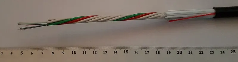
Photo: Asurnipal, CC BY-SA 4.0, via Wikimedia Commons
When federal legislators passed the Infrastructure Investment and Jobs Act in 2021, allocating $65 billion toward closing the rural broadband gap, the conversation centered almost entirely on human connectivity—remote workers, underserved students, rural hospitals struggling with telemedicine limitations. What received almost no attention was the physical geography of the infrastructure required to deliver those benefits. Fiber optic lines do not travel through the digital ether. They are buried in trenches, suspended on poles, and routed through terrain that, in many parts of rural America, represents some of the most ecologically intact land remaining on the continent.
Geospatial researchers are now beginning to map what that deployment looks like from a conservation perspective—and the picture is considerably more complicated than broadband advocates have acknowledged.
Measuring Intactness Before It Disappears
The concept of landscape intactness has become a foundational metric in conservation science. Intact landscapes are defined not merely by the absence of urban development but by the degree to which natural ecological processes—predator-prey dynamics, hydrological cycles, seed dispersal, wildlife migration—continue to function without significant human disruption. GIS-based intactness indices, developed by organizations including the Wildlife Conservation Society and various federal agencies, use satellite-derived land cover data, road density layers, and human footprint models to identify where these conditions still exist.
By these measures, the United States retains a surprisingly limited inventory of genuinely intact wildland. Most of it is concentrated in the intermountain West, the northern Rockies, the boreal transition zones of Alaska and northern Minnesota, and scattered across the Appalachian highlands. These are also, not coincidentally, precisely the regions where broadband infrastructure is most deficient—and therefore most targeted for accelerated deployment under current federal programs.
When GIS analysts overlay proposed and active fiber optic corridor maps against intactness indices, the spatial overlap is striking. In states including Montana, Idaho, Wyoming, and New Mexico, fiber routes are being permitted and constructed through zones that score among the highest in the country for ecological intactness. The corridors themselves may be narrow—a buried conduit requires a trench typically no wider than a few feet—but the associated infrastructure footprint is considerably larger. Access roads, staging areas, utility easements, and vegetation clearing strips can extend the effective disturbance zone to widths of twenty feet or more.
The Cumulative Fragmentation Problem
No single fiber optic trench, considered in isolation, represents a catastrophic ecological event. This is precisely what makes the issue so difficult to address through conventional environmental review processes, which tend to evaluate projects individually rather than cumulatively. The problem that GIS science is uniquely positioned to reveal is the aggregate pattern—what happens when dozens of corridors, each modest in isolation, are mapped together across a regional landscape.
Researchers applying least-cost path modeling to carnivore movement in the northern Rockies have found that even low-intensity linear disturbances can substantially alter the probability of wildlife successfully traversing between habitat patches. Species such as wolverine, Canada lynx, and grizzly bear—all of which require large, connected territories and exhibit strong sensitivity to human activity—are particularly vulnerable. When fiber corridors follow valley bottoms and riparian zones, as they frequently do for engineering and cost reasons, they intersect with the very topographic features that wildlife preferentially use for movement between mountain ranges.
The cumulative fragmentation problem is compounded by a timing dynamic that GIS analysis makes visible. Many of the landscapes now being targeted for fiber deployment have remained intact in part because they were bypassed by earlier infrastructure waves—the railroad corridors of the nineteenth century, the highway buildout of the mid-twentieth century, the energy pipeline expansions of subsequent decades. Each of those waves left its own spatial signature of fragmentation. The areas that survived those earlier pressures did so largely because their terrain, remoteness, or land ownership patterns made them economically unattractive for development. Federal broadband subsidies are now changing that calculus, effectively making it financially viable to route infrastructure through terrain that market forces alone would have left undisturbed.
Spatial Modeling Suggests Alternatives Exist
The conservation case against rural broadband expansion is not straightforward, and researchers working at the intersection of GIS science and infrastructure planning are careful to frame the issue in terms of routing optimization rather than opposition to connectivity itself. The question spatial modeling is well suited to answer is not whether to build broadband infrastructure but where, precisely, to route it in order to minimize ecological cost.
Least-impact corridor analysis—a methodology increasingly applied in pipeline and transmission line siting—can be adapted directly to fiber deployment planning. By integrating wildlife movement probability surfaces, habitat quality indices, existing disturbance layers, and topographic data, GIS models can identify routing alternatives that achieve equivalent connectivity for human communities while avoiding the highest-value wildlife movement zones. In several documented cases, alternative routes identified through this type of analysis added only marginal cost to project budgets while substantially reducing projected impacts on sensitive species.
The barrier to applying these tools is not technical. It is procedural and political. Current environmental review frameworks for broadband infrastructure, particularly for projects receiving federal funding through programs administered by the USDA's ReConnect Program and the FCC's Emergency Connectivity Fund, do not systematically require the kind of cumulative spatial analysis that would reveal corridor-level fragmentation risks. Individual projects fall below the thresholds that trigger comprehensive National Environmental Policy Act review, and state-level permitting processes vary enormously in their capacity to evaluate wildlife connectivity impacts.
A Window That Is Closing
Conservation GIS researchers emphasize that the current moment represents a narrow and rapidly closing opportunity to influence broadband infrastructure deployment before patterns become locked in. Unlike surface roads, which can theoretically be decommissioned and revegetated, fiber optic infrastructure tends to be permanent. Once easements are established and conduits are buried, the legal and physical infrastructure for future capacity expansion along the same corridors is effectively in place. What begins as a single fiber line can become, over subsequent decades, the spine of a much larger disturbance zone.
Satellite monitoring of active construction zones in the rural West is already documenting the early stages of this pattern. Time-series imagery shows vegetation clearing and soil disturbance in roadless areas that appear on no conventional infrastructure map—evidence that fiber deployment is advancing faster than spatial databases are being updated to reflect it.
The science needed to protect these landscapes is not speculative. Least-cost routing models, cumulative impact assessments, and wildlife movement probability surfaces are established methodologies with documented track records in other infrastructure contexts. What is required is the institutional will to apply them before the last unfragmented wildlands in the United States acquire yet another layer of linear infrastructure threading through their cores.
The digital divide is a genuine and serious problem. So is the ecological divide being created in the process of closing it. GIS science suggests these objectives need not be in conflict—provided the spatial analysis is conducted before the trenches are dug rather than after.