Clean Energy, Complex Footprints: What Landscape-Scale Mapping Reveals About Solar Development's Hidden Conservation Costs
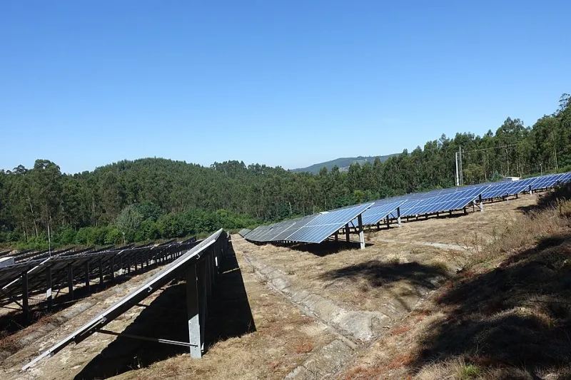
Photo: Joseolgon, CC BY-SA 4.0, via Wikimedia Commons
The energy transition is reshaping the American landscape at a pace and scale that conservation science is only beginning to measure. Utility-scale solar development—installations of one megawatt or larger—now constitutes one of the fastest-growing categories of land use change in the United States. Between 2010 and the early 2020s, the footprint of large solar facilities expanded from a relatively modest base to encompass hundreds of thousands of acres, with federal projections suggesting that achieving national clean energy targets will require many millions more.
This is, by any reasonable accounting, a necessary transition. The ecological consequences of continued fossil fuel combustion are documented, severe, and worsening. But the premise that renewable energy infrastructure is environmentally neutral—or that its land-use effects are negligible relative to its climate benefits—is one that spatial science is beginning to complicate in important and underappreciated ways.
Where Solar Is Landing
The geography of utility-scale solar development in the United States is not random. It is shaped by irradiance levels, land costs, transmission access, and state policy environments. These factors combine to concentrate solar development in specific landscape types: the arid grasslands and shrublands of the Southwest and Southern Plains, the agricultural flatlands of the Southeast, and increasingly the former agricultural and disturbed lands of the Midwest and Mid-Atlantic.
GIS analysis of solar facility footprints—drawn from Federal Energy Regulatory Commission interconnection data, state permitting databases, and remote sensing classification of constructed facilities—reveals several geographic patterns that carry significant conservation implications.
First, a disproportionate share of large solar development is occurring on intact or semi-intact grassland and shrubland ecosystems rather than on previously developed or degraded land. The Western Association of Fish and Wildlife Agencies and several peer-reviewed studies have documented that a substantial fraction of utility-scale solar capacity built through the early 2020s was sited on lands classified as having moderate to high ecological value, including areas supporting threatened grassland bird species and native pollinator communities.
Second, solar development is clustering in ways that amplify cumulative landscape impacts. Individual projects, reviewed in isolation, may appear to have manageable footprints. But spatial overlay analysis reveals that multiple projects in proximity can collectively fragment grassland or shrubland blocks that would otherwise meet the minimum patch-size thresholds required by area-sensitive species. This cumulative fragmentation effect is rarely captured in project-level environmental impact assessments, which are designed to evaluate discrete facilities rather than regional development patterns.
Soil, Water, and the Infrastructure Effect
The physical transformation associated with solar facility construction extends well beyond the panels themselves. Site preparation typically involves grading, vegetation removal, compaction of surface soils, and installation of drainage infrastructure designed to protect equipment from standing water. Each of these modifications alters the hydrological and pedological function of the affected land in ways that persist long after any eventual decommissioning.
LiDAR-based terrain analysis of constructed solar facilities documents measurable changes in surface flow patterns around large installations. Graded sites alter natural drainage gradients, redirecting runoff in ways that can accelerate erosion on downslope parcels, modify recharge patterns for shallow aquifers, and alter the hydrological connectivity of adjacent wetland or riparian systems. These effects are site-specific and variable, but they are not negligible—and they are not routinely modeled during the project approval process.
Soil compaction beneath and around panel arrays has been documented in peer-reviewed literature as reducing infiltration rates and altering microbial community composition. The long-term implications for soil carbon stocks and post-decommissioning land productivity remain insufficiently studied, in part because the industry is young enough that large-scale decommissioning has not yet occurred at significant scale.
The thermal signature of large solar arrays—detectable in satellite-derived land surface temperature products—also raises questions about localized microclimate modification. Dense arrays of dark panels absorb solar radiation that would otherwise be reflected or processed through vegetation, creating measurable surface temperature anomalies. The ecological consequences of these thermal footprints for adjacent native plant communities and soil-dwelling invertebrates are an emerging area of research.
Wildlife Corridors and the Renewable Energy Buildout
Perhaps the most spatially tractable conservation concern associated with utility-scale solar development is its relationship to wildlife movement corridors. Decades of conservation biology research have established that landscape connectivity—the capacity of wildlife to move between habitat patches—is a critical determinant of population viability, genetic diversity, and species resilience to climate change.
GIS overlay analysis of identified wildlife corridors, derived from connectivity modeling products including the Western Governors' Association wildlife corridor frameworks and state-level habitat connectivity assessments, reveals that a meaningful number of proposed and constructed solar facilities are sited within or adjacent to mapped movement corridors for species including pronghorn, mule deer, desert tortoise, and several grassland bird species.
Fencing required for facility security—typically chain-link or woven wire at heights that impede medium and large mammal movement—functions as a barrier even when the surrounding landscape remains nominally intact. A solar facility bisecting a mapped pronghorn migration corridor does not simply occupy the land beneath its panels; it interrupts the movement network across a much larger geographic area.
The cumulative effect of multiple facilities in a corridor zone can be modeled using least-cost path analysis and circuit theory approaches that quantify changes in effective connectivity. Preliminary analyses conducted for specific corridor regions in the Mojave and Sonoran deserts suggest that projected solar buildout under current siting trajectories would meaningfully reduce modeled connectivity for several sensitive species—even in scenarios where individual projects comply with all applicable environmental mitigation requirements.
The Planning Gap
The fundamental problem is not that solar development is occurring. It is that solar development is occurring without the benefit of coordinated, landscape-scale spatial planning that could direct facilities toward lower-sensitivity lands while preserving the ecological functions that make the broader landscape worth protecting.
Several frameworks for doing this exist. The Department of Interior's solar energy zones, established for public lands in the Southwest, represent one model: areas pre-screened for development suitability based on ecological sensitivity, resource conflicts, and transmission proximity. Conservation organizations and academic researchers have developed complementary mapping products that identify previously disturbed or low-ecological-value private lands suitable for solar development without significant conservation tradeoffs.
The challenge is that these frameworks are voluntary, geographically incomplete, and frequently not consulted in state-level permitting processes that govern the majority of solar development on private land. A developer seeking permits in a state with limited environmental review requirements faces no regulatory incentive to consult corridor maps or ecological sensitivity layers that are not formally incorporated into the approval process.
Toward a Spatial Strategy for the Energy Transition
The clean energy transition is not optional. The conservation implications of climate change—habitat loss, phenological disruption, range compression, increased wildfire frequency—are themselves severe threats to the biodiversity that conservation science exists to protect. Solar energy is a necessary component of any credible strategy for limiting those consequences.
But necessity does not preclude planning. The spatial tools required to direct solar development toward lands where its conservation costs are lowest are available, validated, and increasingly accessible. What is required is institutional commitment to using them—through federal siting guidance, state permitting reforms, and financial incentives that reward developers for selecting ecologically appropriate locations.
The energy transition will reshape the American landscape regardless of whether conservation science is incorporated into its planning. The question is whether that reshaping will be guided by the best available spatial knowledge or allowed to proceed by default, accumulating ecological costs that a more deliberate approach could have avoided.