Floodplain by Default: The Spatial Disconnect Undermining America's Buyout-Driven Habitat Opportunity
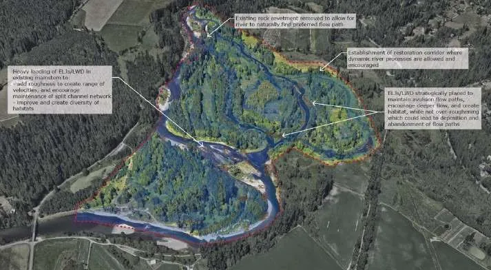
Photo: floodplain restoration riparian corridor aerial view river habitat, via kingcountyfloodcontrol.org
America's floodplains are being returned to nature—not through conservation planning, but through catastrophe. Repeated flooding, intensified by climate change and amplified by decades of floodplain development, has made a growing number of riverside and lowland communities economically untenable. In response, federal programs administered primarily through the Federal Emergency Management Agency and the Department of Housing and Urban Development have spent billions of dollars acquiring flood-damaged properties, relocating residents, and retiring the land from development in perpetuity.
The scale of this transfer is underappreciated. Since the 1990s, federal buyout programs have acquired more than 45,000 properties across the United States, with the pace accelerating markedly following major flood events including Hurricanes Harvey, Irma, and Ida, and the repeated inundations that have struck Midwestern river systems over the past decade. The total acreage involved—concentrated in floodplains, riparian corridors, and coastal lowlands—represents a land base with extraordinary potential ecological value.
Spatial analysis of where these parcels are located, how they are currently managed, and how they relate to adjacent conservation lands reveals a troubling pattern: a historic conservation opportunity is being systematically underutilized because the programs generating it were designed for disaster response, not ecological restoration.
Mapping the Buyout Landscape
FEMA's Hazard Mitigation Grant Program and Flood Mitigation Assistance program maintain databases of acquired properties, though data quality and geographic completeness vary by state and grant cycle. Integrating these records with parcel-level GIS data, land cover classifications, and hydrological network layers produces a spatial picture of the buyout footprint that is both striking and, in conservation terms, deeply instructive.
Buyout parcels are, by definition, located in floodplains—areas that experience repeated inundation and that, prior to development, supported riparian forest, bottomland hardwoods, emergent wetlands, or floodplain meadow ecosystems. Many of these landscape types are among the most ecologically productive and most threatened in North America. Bottomland hardwood forests of the Mississippi Alluvial Valley have been reduced to a fraction of their historical extent. Riparian corridors throughout the Great Plains and Southwest support disproportionate shares of regional biodiversity relative to their land area. Tidal freshwater wetlands along the Atlantic and Gulf coasts provide critical habitat for migratory waterbirds, fish nursery functions, and coastal storm buffering.
When buyout parcels are overlaid with mapped habitat connectivity frameworks—including the Nature Conservancy's resilient and connected landscapes analysis and USGS-derived stream network data—a significant proportion of acquired properties appear within or immediately adjacent to identified priority corridors for wildlife movement and ecological flow. In river systems including the Missouri, the Red, the Tar-Pamlico, and numerous smaller watersheds, buyout parcels form partial but potentially connectable chains of restored floodplain habitat stretching for miles along stream channels.
The Management Vacuum
The ecological potential of these lands is, however, largely unrealized. Federal buyout programs require that acquired properties be maintained as open space in perpetuity and prohibit reconstruction of structures. Beyond these negative constraints, the programs provide limited guidance, funding, or coordination for active ecological management.
In practice, this means that many buyout parcels are managed—if that word applies—by the municipality or county that holds title following acquisition. Local governments, already resource-constrained and focused on the administrative challenges of property acquisition and resident relocation, rarely have the capacity or expertise to implement ecological restoration plans. Parcels are frequently maintained as mowed grass, allowed to succeed to invasive shrub communities, or simply left without active management of any kind.
The result, documented through time-series analysis of land cover classification applied to buyout parcel locations, is that a substantial fraction of acquired floodplain land is not recovering toward ecologically functional native communities. Instead, it is occupying an intermediate state—no longer developed, but not meaningfully restored—that provides limited wildlife habitat value and fails to deliver the full suite of ecosystem services that functional floodplain systems generate.
This management vacuum is not a technical failure. It is a structural one. The programs that generate buyout land were designed to reduce flood risk and remove people from harm's way. Conservation outcomes were never their primary objective, and their funding structures, administrative protocols, and interagency relationships reflect that original purpose.
Connectivity Lost and Found
The conservation science of landscape connectivity provides a framework for understanding both what is being lost and what could be recovered. Wildlife movement networks are not simply collections of habitat patches; they are functional systems in which the spatial arrangement of patches, the quality of the intervening matrix, and the presence or absence of movement barriers collectively determine whether populations can persist, disperse, and adapt to changing conditions.
Floodplains are natural movement corridors. Rivers and their associated riparian vegetation have historically channeled the movement of mammals, birds, amphibians, and invertebrates across landscapes that would otherwise be difficult to traverse. Restoring floodplain function along even fragmented river reaches can substantially increase the connectivity value of the broader landscape—but only if restoration is planned with connectivity as an explicit objective and implemented in a spatially coordinated manner.
GIS-based connectivity modeling applied to river systems with significant buyout footprints reveals a consistent pattern: individual buyout parcels, managed in isolation, contribute minimally to modeled connectivity. The same parcels, managed in coordination with adjacent conservation lands, riparian buffer strips, and strategically placed easements on intervening private properties, can function as components of continuous movement corridors with measurable value for target species.
The difference between these two outcomes is not primarily financial—restoration of native vegetation communities on buyout parcels is not prohibitively expensive relative to the cost of the acquisitions themselves. The difference is organizational. It requires that the agencies managing buyout programs communicate and coordinate with state wildlife agencies, conservation land trusts, and federal conservation programs in ways that current administrative structures do not facilitate.
A Federal Opportunity Requiring Federal Coordination
Several existing federal programs could, in principle, provide the conservation management capacity that buyout programs lack. The USDA's Wetlands Reserve Easement program, the Natural Resources Conservation Service's floodplain restoration initiatives, and the Fish and Wildlife Service's Partners for Fish and Wildlife program all fund ecological restoration on private and public lands. State wildlife agencies manage riparian restoration programs with technical expertise directly applicable to buyout parcel management.
What is absent is a formal mechanism for connecting these programs to the buyout land base in a spatially coordinated way. A property acquired through FEMA's hazard mitigation program does not automatically enter the awareness of NRCS restoration planners or state wildlife agency habitat coordinators. The data systems of these agencies are not routinely integrated, and interagency coordination protocols for floodplain restoration are underdeveloped relative to the scale of the opportunity.
Building that coordination would require relatively modest investments in data integration, interagency communication infrastructure, and planning capacity. A national GIS platform linking buyout parcel locations with conservation priority mapping, connectivity models, and existing restoration program footprints would provide the spatial foundation for coordinated floodplain restoration planning at the watershed scale.
The Window Is Open, but Not Indefinitely
Climate projections are unambiguous on one point: flood frequency and intensity will continue to increase across much of the United States for the foreseeable future. Buyout programs will continue to acquire floodplain land. The ecological opportunity embedded in that process will continue to grow.
But opportunity is not self-executing. Every year that acquired parcels remain unrestored is a year in which invasive species establish, soil structure degrades further, and the seed banks and microbial communities that support native vegetation recovery diminish. The window for cost-effective restoration narrows with each passing season of neglect.
Conservation GIS science exists precisely to make visible the spatial relationships that administrative fragmentation obscures. The buyout land base, mapped against connectivity frameworks and restoration priority layers, reveals not a collection of isolated problem properties but the skeleton of a functioning floodplain network waiting to be reassembled. Recognizing it as such—and organizing the institutional response accordingly—is among the most consequential conservation planning decisions available to American land management agencies in the coming decade.