Death by a Thousand Subdivisions: Spatial Science Exposes the Cumulative Habitat Toll of Low-Density Sprawl
Suburban sprawl rarely announces itself with the blunt force of a highway interchange or an industrial complex. A single cul-de-sac, a cluster of five-acre lots, a strip of retention ponds and decorative landscaping—none of these individually registers as a conservation emergency. Yet geographic information systems research increasingly demonstrates that dispersed, low-density development fractures ecosystems with a quiet efficiency that concentrated development seldom matches. Across the American South and Midwest, spatial analysis is assembling the cumulative picture, and the findings are reshaping how conservation scientists think about land-use policy.
The Measurement Problem That Hid the Crisis
For decades, environmental impact assessments focused on discrete projects: a specific mine, a designated wetland fill, a pipeline corridor of defined width. That project-by-project framework made administrative sense, but it was cartographically blind to a different kind of harm. Low-density residential development does not arrive as a single event with a single footprint. It accumulates across years and jurisdictions, parcel by parcel, each transaction individually below the threshold of regulatory scrutiny.
The result was a systematic undercounting. State wildlife agencies tracking habitat loss were measuring individual clearings while missing the connective tissue being severed between them. Traditional land-cover datasets captured what was built but not what was functionally severed—the difference between a forest that appears intact on a land-cover map and one that has been rendered ecologically impassable by a surrounding matrix of low-density lots, road networks, and domestic disturbance zones.
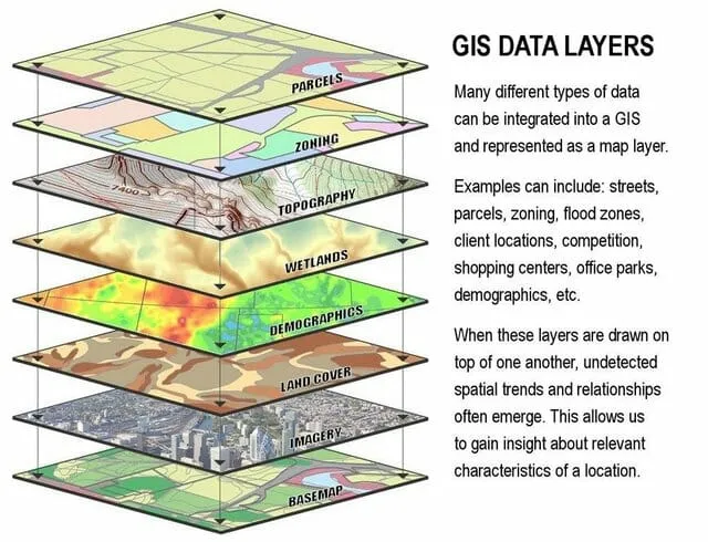
GIS changed that calculus. By layering parcel-level development records over time-series satellite imagery and overlaying the combined dataset against species movement models, researchers can now quantify not just what land was converted but what functional relationships were broken in the process.
Mapping the Invisible in the South and Midwest
Consider the Piedmont region stretching from northern Georgia through the Carolinas—a landscape that hosts some of the highest plant biodiversity in the temperate United States and serves as a critical movement corridor for white-tailed deer, black bear, and dozens of migratory songbird species. Aerial photography from the 1970s shows a mosaic of forest patches, agricultural fields, and small towns. Contemporary land-cover analysis of the same area reveals something superficially similar: forest cover percentages have not collapsed catastrophically. What the raw numbers obscure is the structural transformation that GIS patch-connectivity analysis makes visible.
Researchers applying graph-theory-based connectivity models to the Piedmont landscape have documented that the average functional corridor width—the usable passage available to a mid-sized mammal moving between forest patches—has decreased by more than 60 percent in some counties over the past four decades. The forest is still there, technically. But it has been subdivided into a mosaic of remnant patches surrounded by low-density residential development, with each patch increasingly isolated from its neighbors by roads, fences, domestic dogs, artificial lighting, and the simple behavioral aversion that many species show toward human-modified environments.
The Midwest presents a structurally parallel story with different ecological stakes. The oak savanna and tallgrass prairie remnants of Illinois, Indiana, and southern Wisconsin are among the most endangered ecosystems in North America—less than one percent of original extent survives. What does survive is under pressure not primarily from large-scale agricultural conversion, which largely concluded generations ago, but from the gradual encroachment of low-density exurban development as metropolitan areas like Chicago, Indianapolis, and Milwaukee extend their gravitational pull across the surrounding countryside.
GIS analysis of land-use change in the Chicago metropolitan fringe, conducted using county parcel records merged with National Land Cover Database time-series data, shows that between 2001 and 2019, low-density residential parcels of one to ten acres expanded across more than 340,000 acres in a six-county ring around the city. No single transaction in that dataset would have triggered a federal environmental review. Collectively, they restructured the landscape ecology of a region that contains the majority of remaining high-quality prairie remnants in the state of Illinois.
What Gets Lost: Genetic Corridors and Plant Community Integrity
The ecological cost most frequently cited in sprawl discussions is mammal movement—bears, bobcats, and deer unable to disperse across fragmented landscapes. That framing, while accurate, understates the breadth of the damage that spatial analysis is now documenting.
Plant genetic diversity is a less visible casualty. Many native plant species depend on animal-mediated seed dispersal or pollinator movement across distances of several miles to maintain genetically viable populations. When low-density development interrupts those movement pathways, plant populations do not immediately disappear. They persist in place, sometimes for decades, before the genetic consequences of isolation become apparent in reduced reproductive success and diminished resilience to environmental stress.
GIS-based landscape genetics studies, which overlay genetic sampling data from plant populations against spatial models of connectivity, are beginning to quantify this effect with precision. Work conducted in the oak woodlands of the Ozark Plateau has identified measurable genetic differentiation between populations separated by as little as three to five miles of low-density suburban matrix—distances that would have been ecologically trivial in a less fragmented landscape. The implication is that sprawl is not merely reducing habitat quantity; it is quietly degrading the genetic architecture of plant communities that took thousands of years to assemble.
The Policy Lag and What Spatial Science Offers
Environmental regulation in the United States was built around the concept of the significant individual action. The National Environmental Policy Act, the Clean Water Act's Section 404 program, and most state-level equivalents operate through project-level review. That architecture has real value, but it is structurally incapable of capturing cumulative, dispersed harm—which is precisely what low-density sprawl produces.
The spatial science community has spent the past two decades developing tools that could, in principle, fill that gap. Cumulative impact assessment frameworks using GIS allow analysts to model the aggregate connectivity consequences of a proposed development pattern before permits are issued, rather than reviewing each parcel in isolation. Scenario modeling tools can compare alternative zoning configurations—clustered development that preserves functional corridors versus dispersed development that severs them—and quantify the difference in ecological outcomes with a rigor that supports regulatory defensibility.
Several states are beginning to integrate these approaches into their planning frameworks. Maryland's Program Open Space has used connectivity modeling to prioritize land acquisitions that fill functional gaps in the state's wildlife corridor network. North Carolina's Natural Heritage Program maintains a GIS-based biodiversity mapping system that local governments can use to identify high-priority conservation areas before rezoning decisions are finalized.
These are meaningful steps, but they remain voluntary, patchwork, and dependent on local political will. The scientific infrastructure to measure cumulative sprawl impacts now exists. The regulatory infrastructure to act on those measurements does not yet match it.
Redefining What Counts as Environmental Harm
The central contribution that GIS science makes to the sprawl debate is not technical—it is conceptual. By making the cumulative footprint of dispersed development visible in a single spatial frame, it challenges the intuitive but ecologically misleading idea that small actions produce small consequences.
A subdivision of forty homes on five-acre lots does not look, from the ground or from a planning commission meeting room, like an environmental emergency. Mapped against the functional connectivity network of the surrounding landscape, placed in the context of thirty similar subdivisions approved in the same watershed over the preceding fifteen years, and overlaid with species movement data and plant genetic sampling results, it can look like exactly that.
Conservation science has long understood that landscapes must be managed at the scale of ecological processes rather than administrative convenience. Geographic information systems have finally given that principle an evidentiary foundation capable of informing law and policy. The remaining challenge is institutional: persuading the regulatory systems that govern American land use to look at the map that spatial science has spent a generation assembling.