Wired for Disruption: The Quiet Fragmentation of America's Forests by Transmission Line Corridors
America's electrical grid is one of the most consequential engineering achievements in human history. It delivers power to hundreds of millions of people, drives the national economy, and is now at the center of a massive expansion campaign tied to clean energy transition. Yet beneath the policy ambitions and engineering specifications lies a geographic reality that conservation scientists are only beginning to quantify with precision: transmission line corridors are fragmenting forest ecosystems across the continental United States at a scale that rivals—and in some regions surpasses—the documented impacts of the highway system.
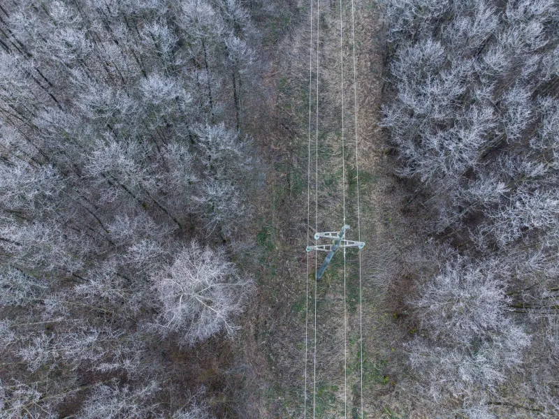
The corridors themselves are easy to overlook. Cleared to widths ranging from 50 to 150 feet, they do not carry the visual weight of an interstate or a suburban development boundary. From the air, they appear as thin incisions threading through otherwise intact woodland. On the ground, however, they function as something considerably more consequential: persistent linear disturbances that interrupt canopy continuity, alter microclimate conditions, introduce invasive plant species, and reconfigure the behavioral geography of forest-dependent wildlife.
When those incisions are mapped at the national scale, the picture changes dramatically.
Quantifying a Network That Spans Continents
The United States maintains approximately 160,000 miles of high-voltage transmission lines, a figure that does not account for the far more extensive network of lower-voltage distribution infrastructure woven through rural and forested landscapes. Geospatial analysis drawing on utility easement records, federal land management data, and satellite-derived canopy cover datasets reveals that this infrastructure intersects some of the most ecologically sensitive terrain in the country—the interior forests of the Appalachians, the upper Great Lakes region, the boreal transition zones of northern Minnesota and Maine, and the mixed conifer forests of the Pacific Northwest.
What makes transmission corridors particularly significant from a fragmentation standpoint is not simply their length but their persistence and maintenance regime. Unlike a forest road that may eventually revegetate if abandoned, transmission corridors are subject to regular mechanical and chemical clearing cycles that prevent canopy closure indefinitely. The ecological disturbance is not a one-time event but a permanent condition embedded in the landscape.
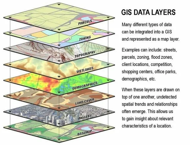
GIS-based edge effect modeling demonstrates that the ecological influence of a cleared transmission corridor extends well beyond its physical footprint. Canopy fragmentation creates abrupt microclimatic transitions—increased wind exposure, elevated temperature variance, reduced humidity—that penetrate 100 to 300 meters into adjacent forest stands depending on corridor orientation and regional climate conditions. When those buffer zones are factored into cumulative impact assessments, the effective ecological footprint of the transmission network expands by an order of magnitude beyond the cleared right-of-way itself.
Where Infrastructure Meets Movement
The intersection of transmission corridors with mapped wildlife movement zones presents some of the most concerning findings to emerge from recent spatial analyses. Least-cost path modeling and connectivity analysis—tools that identify the routes through which wide-ranging species such as black bear, bobcat, fisher, and white-tailed deer navigate fragmented landscapes—consistently flag transmission corridors as movement impediments, particularly in regions where multiple corridors converge or run parallel to roads and other linear infrastructure.
In the central Appalachians, for example, GIS analysis overlaying high-voltage transmission easements with modeled connectivity corridors for forest interior species reveals a pattern of compounding disruption. Transmission lines in this region frequently follow ridge lines and valley edges—precisely the terrain features that wildlife movement models identify as preferred travel routes. The result is a spatial conflict that traditional infrastructure planning has rarely been required to address.
The behavioral dimension of this disruption is significant. Forest interior species—those most sensitive to edge conditions—do not simply reroute around transmission corridors the way a motorist detours around road construction. Research on species such as the wood thrush, the cerulean warbler, and several bat species dependent on contiguous canopy structure indicates that transmission corridors function as soft barriers: not impassable, but sufficiently disruptive to reduce movement frequency, increase predation exposure, and alter foraging and breeding behavior in adjacent habitat patches.
Comparing Corridors: Roads Versus Transmission Lines
The conventional framework for assessing linear infrastructure impacts in conservation science has centered on roads. The road ecology literature is extensive, methodologically sophisticated, and increasingly integrated into regulatory review processes. Transmission corridors, by contrast, have received comparatively limited systematic attention despite occupying a comparable or greater aggregate footprint in many forested regions.
A direct geospatial comparison of road networks and transmission corridors in the northeastern United States illustrates the disparity. In several heavily forested counties across Pennsylvania, New York, and Vermont, the combined cleared width of transmission easements within defined analysis units equals or exceeds the combined cleared width of paved road surfaces. When edge effect buffers are applied to both infrastructure types, transmission corridors account for a disproportionate share of total disturbed area in landscapes where road density is moderate but transmission infrastructure is concentrated.
This is not to suggest that roads present lesser conservation challenges—the mortality, barrier, and pollution effects associated with road networks remain among the most thoroughly documented threats to wildlife populations in North America. Rather, the spatial data argues for a more balanced accounting of linear infrastructure impacts, one that treats transmission corridors as first-order fragmentation agents rather than secondary concerns.
The Clean Energy Complication
The fragmentation challenge posed by transmission infrastructure is likely to intensify in the coming decades. The transition to renewable energy generation—wind and solar facilities often sited in remote or rural landscapes—requires substantial expansion of the transmission network to move power from generation sites to population centers. Federal and state energy agencies are actively planning new high-voltage corridors through some of the most ecologically intact forest landscapes remaining in the eastern United States.
Conservation planners working at the intersection of energy policy and landscape ecology are increasingly turning to GIS-based siting analysis to identify corridor routes that minimize ecological impact. Least-impact routing models can evaluate proposed transmission paths against layers of connectivity data, species distribution models, and forest interior habitat classifications to identify alignments that avoid the most sensitive terrain. These tools exist. The question is whether they will be applied systematically and with sufficient weight in regulatory and planning processes that have historically prioritized engineering and economic criteria.
The clean energy transition presents a genuine tension: the infrastructure required to reduce carbon emissions at scale may impose significant near-term costs on the forest ecosystems that serve as critical carbon sinks and biodiversity refuges. Resolving that tension requires spatial analysis capable of quantifying both sides of the ledger with rigor and transparency.
Toward a More Complete Fragmentation Accounting
The conservation science community has made substantial progress in documenting and communicating the landscape-level impacts of roads, urban development, and agricultural conversion. The spatial tools required to apply that same rigor to transmission infrastructure are fully available—what has been lacking is the systematic application of those tools to a network that has grown largely outside the frame of habitat fragmentation science.
National-scale GIS analysis integrating utility easement data, high-resolution canopy cover mapping, wildlife movement models, and edge effect parameters could produce the kind of comprehensive fragmentation accounting that transmission infrastructure has not yet received. Such an analysis would not argue against electrical infrastructure as such—the grid is essential, and its expansion in support of clean energy is a legitimate policy objective. It would, however, establish a more accurate baseline for understanding where the ecological costs of that infrastructure are concentrated, and where alternative routing, co-location with existing disturbed corridors, or targeted mitigation investments could reduce those costs substantially.
The invisible grid is not, in fact, invisible to the species navigating the forests it traverses. Making it visible to conservation science and infrastructure planning is an achievable and necessary step.